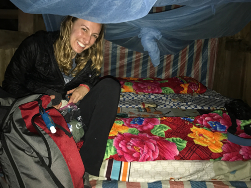
An overnight train combined with hours of carefully teetering over rice fields in the mountains of Sapa left us exhausted. Sam led the way up one last hill in the village of Ta Van to our home for the night. We’d opted to stay in a local house, but didn’t fully understand what that meant until we arrived.
“Hello” was one of the few English words our host spoke. Sam motioned to us to remove our boots and put on slippers as to not get the house dirty. It was dark except for the fire pit in the kitchen. Our host squatted back down over the fire, stirring the vegetables we’d soon eat. The house was large, but empty. The kitchen had only a few low stoops for sitting, a trash can filled with rice, a wooden table for meal prep, and a cabinet with small bowls and chopsticks. A waterspout in the corner was used for washing dishes. There were five red plastic chairs and a folding table that moved from room to room depending on the need. The living room and two beds were not separated by a wall. Behind the TV there was a ladder to the loft where we found two hard mats and a thick blanket: our bedroom. The bathroom was outside and the porch had the most magical view overlooking the village.
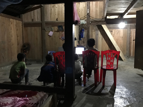
Sam joined our host by the fire. A little boy wandered in watching videos on a cellphone, the only other light in the room. We drank Coca-Colas outside and listened as the oldest of her three sons motioned to us to come and eat. On the folding table was now a spread of chicken with onions, pork with carrots, tofu with chilis, greens, and a mound of white rice. We scooped rice into small bowls and picked at the rest with chopsticks, watching as her sons ate quietly and quickly, eager to get back to their friends in the living room still watching TV. Our host’s husband came home just as we were finishing and insisted on sharing shot after shot of homemade rice wine served out of an Aquafina water bottle.Not long after the power went out, the boys scattered, and everyone grabbed their headlamps. One single candle was lit in the center of the table.
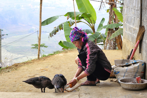
We slept so well that night, waking early to the sounds of roosters spread across Ta Van. Ducks wandered quietly into the kitchen as we sat outside drinking coffee. They were shooed away, then fed dried corn off the cob. Our host went back to cooking the pig breakfast. We felt so well cared for in her home. We were struck by the obvious: This is very different, but how different was it really? Little boys still watched TV, played with cars, and made swords out of bamboo. The family ate dinner together, talked late into the night, and took care of one another. Even in seemingly tougher areas, home is still home.
While still in Istanbul, Adam and I heard stories from other travelers of the various treks in southern Morocco, and soon after entering our Riad, we found a poster with photos of camels, sand dunes, and Berber villages. Convincing us to go may have been one of the easiest sells that the Riad had to do.
Our route took us from Ait Benhaddou to Ouarzazate to La Vallee des Roses to Les Gorges de Dades, where we spent the first night. The second day we traveled to Les Gorges de Todra, then to Merzouga, and finally took camels to the middle of the desert in Bivouac, where we spent the second night. The final day we had a long journey back to Marrakech.
In the Berber village, we all received the hard sell in a traditional home for a handmade rugs. After a couple rounds of tea, getting to know the Berber family, and eventually being shown many colorful rugs, I found one that I liked, bargained the price down, and made a semi-impulsive buy.
Later in the journey, the western Sahara lived up to expectations. The sand dunes looked like ocean waves, except that they begged to be climbed. And with one high-reaching dune next to our camp site tempting the group to climb it, we couldn’t resist. About half way up the dune, we realized that this was going to be more difficult that we originally assessed. For each step upward, we slipped slightly downwards as well. And as I eventually starting crawling up the mountain because of its increasing slope, each planted claw would cause a miniature land slide just around it. Eventually, one of the group members, a physically fit individual from Argentina reached the top of the hill giving me a clear target to reach. I summit the hill while I am well out of breath and inspired by the surrounding sand in every direction.
The night ends with me on a thin mattress covered by a blanket staring up at constellations unfaded by street lights or even by the moon. The slight breeze against my face felt perfect as I drifted off to sleep.
The Big Dipper puts me to sleep in the Western Sahara.
I always try to manage my expectations so that they can be met or exceeded. However, with the ABC trek, my expectations of Base Camp continue to escalate with every meter gained in altitude. And more specifically, my expectations of sunset and sunrise dominate my thoughts of our final destination. I hope sunrise will be perfect because most mornings thus far have been almost perfectly clear, and greedily, I hope we are lucky for sunset, as many of the afternoons have been cloudy and rainy. Both events exceed expectations.
In the afternoon, a cloud swallows base camp and visibility drops to nothing; however, just before sunset, the clouds part showing off the peaks of the surrounding mountains. The clouds that remain are only additive to the sun’s wave goodbye. The line separating white from gold on the mountains slowly ascends as the sun continues to drop. The blue of the sky, which I thought couldn’t be any deeper, slips to navy, midnight blue, and eventually black letting stars I never knew existed start to appear. Fully half-satisfied, I begin my prayers for an equally successful sunrise in the morning. I predict that such a sunrise would meet my elevated expectations and be a lifetime memory.
Waking up as the sky begins to light and layering myself in wool, down jackets, scarfs, gloves, and anything else that would fit to protect myself against this below freezing weather, I venture outside to find no clouds and a perfectly clear, crisp sky. Despite my finger tips starting to lose feeling because I refuse to put down my camera, I am prepared for something special. I investigate the landscape to figure out what spot to be in and when during the next two hours as the sun would rise above the mountains eventually lighting and warming the Annapurna Sanctuary. Now I have a rough morning plan, my camera, the perfect weather conditions, and a big smile.
The first mountain tip, which sits around 8000 meters high starts to shine like the first candle of many. All heads at base camp turn to respect this first light. Soon the second and third peaks are illuminated and the sunlight starts its journey down to the base of the Sanctuary. We all patiently wait for the warming rays of the sun while trying to keep our hands and noses warm by blowing into cupped gloves. Almost too quickly, the sun reaches the floor of Base Camp and the sky starts taking on that unrealistic blue from the night before. The color in my photos will look as if photoshop might be responsible, but it’s natural. The blue’s richness seem as though it should allow constellations to show through, and although the moon remains very visible, the stars do not. I continue to spin and marvel at the mountains around me until I warm up, take a couple too many photos, and feel ready for breakfast.
The sun performs for us at our trek’s destination making the Annapurna Sanctuary feel like it’s on top of the world.
Days four and five along the trek easily presented the greatest challenge, and luckily, Subash had indicated as such from the beginning. Because of the forewarning, I told my traveling musicians to wait back control-wheel until they were called forward. Day four began with a steady downhill, but after reaching the valley’s river, the climbing began and it was time for some of my favorite artists to make their headphone-jack call. One by one, after receiving their signal, the tunes began playing from headphone left and headphone right. The awards for most motivational, energizing and inspirational probably belong to Michael Jackson and Mika, but Neil Diamond, Paul Simon, Cee-lo Green, Chris Brown, Aerosmith, Black Eyed Peas, Fatboy Slim, George Michael, and Journey also deserve praise. They all started playing on day four, but were kind enough to save some energy for their encore performances the following day.
The trail is full of surprises with what gets carried up and back down and with the types of activities that can be seen nearby. Goats, cats, dogs, donkeys, ponies, buffalo, chickens, and roosters are all common sites, and unfortunately, that means their excrement is also. Fifty kilogram wood lodge-building beams, raw yak meat, cans and bottles full of Coke, Fanta and Sprite, and bamboo baskets filled with everything else passes by us in both directions. There are no roads and helicopters are too expensive, so everything is either carried by donkeys, and when donkeys are unavailable and/or the cargo too heavy, porters carry it using two thin shoulder straps and one large forehead ribbon. It’s hard for anyone to complain of fatigue after witnessing this.
Portoculture (n.) – the study of guides and porters who trek through Nepal (etymology: derived by combining the words porter and culture, the term portoculture was not in use until 2011).
Scenario 1: Food/Drink Service
At each of the lodges, all food orders were placed with the trekkers’ respective guides and porters, the order was then relayed to the kitchen, eventually the food was given to the guide, and finally the meal was delivered to the trekker by the guide. This same relay system also occurred when it came time to pay. Although it seems inefficient, this is part of the service structure that has been set up over a long period of time, and it was how I operated with Subash probably about 90 to 95% of the time.
–
Scenario 2: Card Games
Many days, trekkers and their guides arrive early to their destination and are faced with the task of passing the time. Domal and Dalmara (I probably butchered the spelling here) are two card games that the Nepali guides taught me over several afternoons of looking for ways to stay busy. One afternoon, I learned a third card game and when I indicated that I was ready to play, the guide told me that they were gambling. I asked how they were gambling if no money was changing hands and no one was recording the results of the games. He responded vaguely by saying that they were keeping track in their heads. I waited a little longer to see what happens, and eventually he won a hand, so I asked him how much money that earned him. He avoided my question. Then I realized by gambling he meant try to take the silly foreigner’s money. To let him know that I caught on without saying so directly, later in the evening, I asked how much he won or lost. He said that he had broken even. I just smiled.
The next day, the same guide ended up at our lodge again, and this time I had started a game of cards with my own deck. We were playing Domal and not for money. He indicated that he wanted to gamble again. I made him spell out the rules very carefully. We bet 5 rupees on each game, and by the end of the hour, I was up 65 rupees (almost 1 USD). Gambling did make the game more exciting (probably because I was winning), and made the afternoon go very quickly.
–
Scenario 3: Dal Bhat
Dal Bhat is a meal consisting of rice, lentil soup, curry, and vegetables. I ate many throughout my trek because it was the only dish that kept coming until I was full. Bottomless Dal Bhat can fill up anyone. This was also the meal that the guides would eat at least two and sometimes three times a day. It was identical to what we ate, except they always used their right hand to eat, and eating curry, rice, and soup with a hand is an impressive feat.
–
Scenario 4: Guide to Guide Loyalty
The guides are very loyal to each other and to “the business.” As I was making friends along the trail, one morning Subash turned to me and asked if we talked about “the business.” I had an idea to what he was referring, but acted otherwise and said no and asked him what the business was. He was referring to the business of trekking operators, their costs, their programs, and their perks. He then proceeded to say that the guides are angered when we talk of such things. I wanted to tell him that when you have over 100 businesses offering almost identical services, it is hard not to price compare in a capitalistic society, but I just nodded and said thanks for letting me know.
Another example of guide to guide loyalty occurred one evening when I was talking to a guide who had previously worked with the owner of my trekking operator. He was describing treks off the beaten path, seeing another part of Nepali culture, and walking paths that were just opening up to the public. When I asked for his email and contact information for the next time I visit Nepal, he refused to give it to me. He explained I should talk to my current trekking operator and ask for him. I told him I understood his concerns and that we could exchange contact information as friends and that I would not tell anyone we had done so. The next morning he reluctantly gave me his information.
With Nayapul as the heart, the artery and vein of my journey can be traced as red and blue. Click map to enlarge
Day 1
Start: Nayapul (1070 m)
Lunch: Sudame
Destination: Tikhedhungga (1540 m)
Lodge: Chandra Guest House
Trek difficulty: Easy to breathe and easy to walk though there was some climbing. The day was overcast and the temperatures remained moderate.
Highlight: The highlight today was getting to know the other trekkers doing similar routes to me. There was a Japanese woman with a Nepali boyfriend staying at my same lodge. There was a man from Hong Kong also traveling solo, and although he seemed too cool to talk to anyone, I tried anyway. To pass the time, Subash taught me a couple fun Nepali card games that I would be able to use to impress the other guides and porters over the duration of the trek. And I met Paula from Chicago. She was staying at the lodge next door, and I realized we had taken the same bus from Kathmandu. We shared stories over some chicken curry and banana pancakes before heading to bed early so that we would be ready to go bright and early the next morning.
Day 2
Start: Tikhedhungga
Lunch: Nangge Thanti
Destination: Ghorepani (2860 m)
Lodge: Sunny Hotel
Trek difficulty: The first two hours were all at a challengingly steep incline. Afterwards, the path remained semi-level or slightly uphill.
Highlight: The two highlights from today were recognizing that I was, in fact, climbing through the Himalayas from the first two hours of intense climbing. These hours let both my lungs and my water bottles feel their wrath. Before lunch I went through 3 liters of water and didn’t even feel I had to go to the bathroom because I lost all that water while perspiring. The second highlight was at my Ghorepani Lodge, where I played cards with some of the guides, porters, and Grace and Eva (both from Hong Kong), and I had a chance to play basketball with the local Nepali children as the sun set shining on the snow-capped mountains.
Day 3
Start: Ghorepani
Sunrise hike: Poon Hill (3193 m)
Lunch: Ban Thanti
Destination: Tadapani (2630 m)
Lodge: Himalaya
Trek difficulty: Today was an easy day that started early with the sunrise walk and ended early in Tadapani. The hike to the top of Poon Hill was steep, but it lasted less than an hour.
Highlight: Watching the sun touch one mountain peak at a time as it climbed into the sky was surreal and very photogenic. After it rained much of last night, the sky was almost perfectly clear, with just a couple clouds to provide the rays of sun more surfaces to light. In addition, after a nice walk through the forest and along a river, I spent the afternoon and evening playing cards and learning the stories of the other trekkers, guides, and porters also staying in Tadapani. The temporary Tadapani community we created felt so natural and warm that I was sorry to leave it behind the next day, but maybe it was its ephemeral quality that made the community all the more special.
Day 4
Start: Tadapani
Lunch: Chhomrong
Destination: Sinuwa (2360 m)
Lodge: Sinuwa Lodge
Trek difficulty: Tough! Although we lost almost 300 m in altitude, we did so by making our way through two valleys– down, up, back down, and back up. I was exhausted. Upon arriving, I needed a Coca-Cola’s worth of sugar to be functional enough to change into warmer clothes and get ready for dinner. The rain during the second half of the day added to the challenge as the trail because slippery and my rain coat uncomfortable.
Highlight: Subash and I are the first to arrive at our lodge, and after gaining back some energy from the day, I asked Subash if he thought that others would be coming. He didn’t know. I see a couple pass by, hesitate, and the look around, The owner of the lodge runs outside and says something in Napali to their guide. I watch hopeful that they might choose the lodge. They start to walk away, the lodge owner disappears into the kitchen, and then I see them hesitate again and turn around. I yell to the owner that they are coming back and she smiles at me and goes back outside. These two trekkers from Belgium will be my hiking buddies and eventually good friends as we all make our way up to ABC.
Day 5
Start: Sinuwa
Lunch: Himalaya (2920 m)
Destination: Deurali (3230 m)
Lodge: Panorama Guest House
Trek difficulty: Difficult and again it is up and down and up and down. The Annapurna trek doesn’t believe in flat. Even at the end of today’s hike when we are eye level with our lodge, we need to climb up, down, and then back up again before reaching our destination. That said, a slow and steady pace made the day more than manageable. I felt much better after day 5 than I did after day 4.
Highlight: The sun was out most of the day, the views were beautiful, and I was finding my “trekking groove”. It is also a great feeling when I was able to arrive to my lodge just before bad weather rolled in and that is exactly what happened today. Minutes after getting to the Panorama Guest House, visibility drops to nothing, the temperature falls, and rain drops start appearing. Again, the small group staying at my same lodge was very friendly, and many of them enlightened me about the famous climbers who had attempted the famous Himalayan peaks.
Day 6
Start: Deurali
Destination: Annapurna Base Camp (4130 m)
Lodge: Annapurna Sanctuary Lodge
Trek difficulty: Although the path itself presented with only moderately difficult inclines, the continual rise in altitude made this last day to our destination a true challenge. Luckily, it was only a half day and the motivation of knowing what lay ahead was enough to keep me going strong.
Highlight: The highlight today was watching the clouds clear as the sun was setting. I forgot about the tough times getting there, I forgot about the mitten I had lost earlier that day on the trail, and I forgot about the challenges that were ahead in getting back down the mountain. At the moment, surrounded on all sides by white mountains towering at around 8000 meters high, there was no where else I rather be. The sky was changing colors while I walked around the Annapurna Sanctuary seeking out the perfect perfect of this uncapturable moment. The sun sets, I go back into the lodge’s dining room, have some pizza and a lot of hot masala tea while the guides and guests all play cards, Yatzy, and compare stories of our journeys to the top.
Day 7
Start: Annapurna Base Camp
Lunch: Dobhan
Destination: Sinuwa (2360 m)
Lodge: Sinuwa Lodge
Trek difficulty: Much harder than I had anticipated. A long day of mostly downhill can be brutal on knees, ankles, and feet. And the difficulty of downhill is only compounded when it starts to rain as it did for the second half of the day.
Highlight: Waking up at 5am for the moment I had awaited the whole journey had to be the highlight of the day. As the Annapurna Sanctuary warmed up while the sun climbed over the mountains, I wish I could’ve been there forever. However, at around 8am, the descent back down began. Climbing down almost 2000 meters and unfortunately with a lot of interspersed uphill made for a sore evening. For dinner, I had some tomato soup with gurung bread to warm up, but as I ate, I could not shake the anxiety of what tomorrow would be like if my joints didn’t feel better. A highlight, though, would have to be after reaching Sinuwa, where I arrived to a full lodge of excited trekkers both on their way up and back down the mountain. This was the first evening that I crossed paths with a group of 8 Australian trekkers, who would end up being some of the best trekking partners. I would eventually get to know all eight of them plus their 2 guides and 4 porters. They were a wonderful group that I feel so fortunate to have run into.
Day 8
Start: Sinuwa
Destination: Jhinu (1780 m)
Lodge: Jhinu Guest House
Trek difficulty: Today should’ve been one of the easiest day. It was a short distance, all down hill, and the weather was overcast yet dry. Unfortunately, extremely sore knees can turn even the easiest of days into a challenge.
Highlight: My sore knees ended up being both a negative and a positive. A short way down the path, the Australian team came up behind me, recognized the pain I was in, and fixed me up. Tim and Mark gave me a stronger anti-inflammatory and taped up my knee in an attempt to stabilize my patella. Although I didn’t feel 100% afterwards, their tape and medicine worked! I was soon caught up to them and continued with Team Australia to Jhinu. Later that afternoon, soaking my sore knee in the Jhinu Hot Springs was exactly what my muscles craved and I gained a little more confidence about the upcoming days.
Day 9
Start: Jhinu
Destination: Ghandruk (1940 m)
Lodge: Annapurna Guest House
Trek difficulty: Today was downhill for the first third, and uphill for the next two. Again, the trek was only a half day of walking, and luckily for me, the uphill does not hurt my knee in the same way that downhill does.
Highlight: Upon arriving in Ghandruk with the Australian trekking team, we have a big lunch and then walk around the relatively big town. We dress up in wedding gear, and I “get married” to the four Australian women as well as to their assistant guide Tilla (because we happen to be wearing the same hat). The laughs we shared as we all got dressed continued straight into the evening as we all recapped highlights of our trek over some cold Everest Beers. For dinner, I had the most delicious Dal Bhat of the whole trek, and considering this may have been Dal Bhat number 15 of the trek, that is a true recommendation.
Day 10
Start: Ghandruk
Lunch: Birethanti
Destination: Nayapul (1070 m)
Trek difficulty: Today was all downhill and flat, but my knees kept reminding me that they were tired. That said, especially after getting to the flat area, the day went very smoothly and easily.
Highlight: Walking back through the town of Nayapul, I remembered how I felt on that first day. I was nervous and anxious as I had little idea about what was to come and what to expect. Those last 20 minutes after lunch, I felt a sense of accomplishment as well as a tinge of sadness for having completed the trek. I will miss the lodges, the other trekkers, the friendly Nepalese, and getting up for sunrise most mornings to watch as the sun rose over the Himalayas. It was this sadness that made it clear how much I truly enjoyed this adventure.
In preparation of my small, civilized hike in the Himalayas, I chose to get in the mood by watching a couple documentaries on Everest and reading Nick Heil’s “Dark Summit: The True Story of Everest’s Most Controversial Season”.
The first realization was that death is too much of a reality while climbing Everest. Over the last 15 years, Everest’s trek to the summit has claimed on average about 5 lives. And whether that death comes from falling and sliding down some of the highest snow and ice formations on Earth, or whether it is a slow death from hypoxic hypothermia, the risks of making this journey are very real. According to Heil, hypoxic hypothermia is a slow death where initially hands and feet begin to tingle and throb. Eventually, your limbs begin to ache as if being relentlessly squeezed. The brain will start to starve and swell causing slurred speech, poor balance, and finally persistent dementia. Humans are not meant to exist at 29,000 feet, where the summit of Everest resides.
In Nick Heil’s book, to describe the affects of hypoxic hypothermia, he writes:
“As the deep cold intrudes, nerve endings go numb and the pain recedes as circulation retreats toward the core. Often, ironically, it is around this point where freezing feels like being tossed into a furnace. Victims tear at their clothes, throw away gloves and hats, and frantically unzip their parkas, accelerating the slide. Flesh farthest from the heart—toes, fingers, nose, cheeks—freezes first, death advancing from the perimeter. Skin turns pales with frostnip, white during the full throes of frostbite, red and purple with blisters, and ultimately black with gangrene—cellular necrosis, doctors call it, the point at which living tissue is permanently destroyed.
“In the final stages, limbs become insensate and immobile, freezing into place as your body shunts blood toward the lungs and heart, trying to preserve the vital organs. Vision blurs and darkens. Involuntary shivering ensues, a last-ditch attempt to generate heat through movement. You mind swirls deeper into the subconscious, a deep dream state. A few who have returned from the brink of hypothermic oblivion have recounted their last conscious moments as almost pleasurable. ‘You really do start feeling warming,’ Weather wrote in his memoir Left for Dead. ‘I had a sense of floating. I wondered if someone was dragging me across the ice.’
“The ends arrives a few hours later, quietly, in the dark waters of unconsciousness. You blood runs chilled; most brain activity has ceased. The heartbeat slows, fluttering erratically, a wounded bird. This action might continue for a while, the vessel destroyed by the encroaching cold while the heart presses courageously on. At last the pump shuts down, and with that the limited circulation ceases. Internally, there is perfect stillness, equilibrium returning between a delicately calibrated but dissonant energy field in the form of a man and the larger energy field around him—the mountain, the air. The only movement now is wind, ice crystals skittering over rocks and snow, a jacket flap rustling, a clump of hair, stiff with rime, flicking across the forehead.”
Not to worry though, because in contrast, the Annapurna Base Camp Trek, which I am attempting will only take me to a maximum of 13,500 feet. Still a formidable height that will probably cause me to experience some altitude sickness, shortage of breath, and fatigue, but nothing that will threaten my life or necessitate me to bring my own oxygen.
For a little more of the science of altitude sickness, I did a little research. Higher altitudes come with a limited supply of oxygen, and oxygen levels in our blood are determined by the saturation of hemoglobin. After a certain elevation, this oxyhemoglobin begins to decline. Luckily, as amazing as the human body is, we can adapt in many ways, both short term and long term, to the effects of the decrease in oxyhemoglobin. That said, there are theories which show that above 26,000 feet, most humans can no longer acclimatize. This area has come to be known as the “death zone”.
The oxygen saturation of air at sea level is about 21%, and this concentration remains relatively constant until about 21 kilometers up. 21 kilometers is equal to about 70,000 feet, so I’m not planning on having to worry about anything except 21% concentration of oxygen. However, although the percentage stays constant, the atmospheric pressure decreases exponentially with altitude. This lack of oxygen pressure is believed to be the main cause of symptoms of altitude sickness.
I am aware of the symptoms that can arise at high altitudes and I will be careful as I ascend. If I am feeling really bad, I am prepared to stop and see if I start to feel better. A photograph of the final destination is less valuable if I am not around to enjoy it.
So, a Spaniard, a Korean, a French couple, a group of Argentinians, and an American all pile into the back of a truck. The Korean says, “Ko ki o.” The Argentinians go, “Ko lo ro.” The Spaniard replies, “Ki ki ri ki.” The French shoot back, “Cocorico.” And then the American sings, “Cock a doodle doo.” Then, as if answering Alex Trebek, the truck driver turns around and asks, “What sound does a rooster make?” That scene was a bit dramatized for effect; however at some point during our two day trek, we did all compare our languages’ onomatopoeia for the sound made by a rooster. Always a fun discussion when many languages are represented and given that “cock a doodle doo” sounds the farthest from a rooster’s actual sound. As per usual, the group made the trek.
The two days were full of visiting the hill tribes in Northern Thailand, white water and bamboo rafting, sleeping in a hill tribe’s bamboo hut, elephant riding, and waterfall swimming. One of the tribes we visited called the Padaung are famous for their long-necked women. The women undergo a beautifying process throughout their adolescence by adding brass rings to their necks. The effect of the brass rings is to push down the collarbone giving the appearance of an elongated neck. Because eventually their heads are accustomed to being supported by these rings, their necks will atrophy and will be unable to hold the weight of the women’s heads without the rings.
A woman from the longneck tribe in Northern ThailandFloating down the river on a bamboo raft
Another highlight of the journey was around the evening bonfire when the Argentinians picked up the tribe’s guitar and drums and entertained the group.
2:00am. I wake up, jump in the shower because I went to bed shvitzing the night before from the humidity, pack my camera, some water, and a snack, and go outside to wait for the shuttle.
3:00am. The shuttle leaves Sania’s Bungalows in Ubud and is en route to Batur Volcano.
4:15am. Arrive at Batur Volcano, have a cold fried banana and some tea, meet my trekking team consisting of a guide, three young travelers from Germany and myself, and start hiking up the mountain.
5:00am. I really start to shvitz.
5:45am. Dawn has broken and my flashlight is no longer as necessary.
6:00am. Nearing the top of the mountain, shvitzing like crazy, and starting to bond with my hiking team.
6:15am. We made it to the highest point along Batur Volcano’s crater.
6:30am. We enjoy the sunrise!
6:45am. Body temperature drops quickly, and I start to slightly shiver as I am still drenched in shvitz. Breakfast consists of eggs hardboiled using the Volcano’s escaping steam, a banana sandwich, and hot tea.
7:00am. Find a hot steam vent from the Volcano and try to prevent further shivering.
7:30am. We start our way around the rim of the crater occasionally quickening my heart rate because of the steep slope to both my left and right as I walk.
8:00am. The sun is now out and the shvitz is back.
My team at the top of the Batur Volcano
9:00am. Finish walking around the entire crater and head back down the mountain.
10:00am. Part ways with my new found friends, jump in the shuttle, and prepare for my next adventure.